
Research Projects
Synthetic Evaluation of Infrasonic Multipole Waveform Inversion
|
Acoustic source inversions estimate the mass flow rate of volcanic explosions or yield of chemical explosions and provide insight into potential source directionality. However, the limitations of applying these methods to complex sources and their ability to resolve a stable solution have not been investigated in detail.
We perform synthetic infrasound waveform inversions that use 3-D Green’s functions for a variety of idealized and realistic deployment scenarios using both a flat plane and Yasur volcano, Vanuatu as examples. We systematically vary the number and configuration of stations, degree of directionality, source frequency, noise level, and atmospheric conditions and determine their impact on source inversion results. Synthetic inversion studies such as this can help investigate the limitations and place bounds on information that may be missing using monopole and multipole inversions for potentially directional sources (e.g. volcanic explosions, buried chemical explosions, and mass movements). Related Publications: Iezzi, A.M., Matoza, R.S., Fee, D., Kim, K., and Jolly, A.D. (2022), Synthetic Evaluation of Infrasonic Multipole Waveform Inversion, Journal of Geophysical Research: Solid Earth, 127. | (link) |
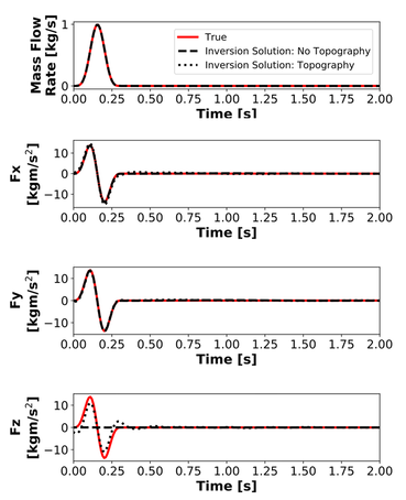
Multipole inversion results for inversions with and without topography. Mass flow rate and horizontal dipole components are recovered well, but the vertical dipole component is difficult to resolve. Figure from Iezzi et al. (2022), JGR
|
Seismo-Acoustic Characterization of Explosion Signals
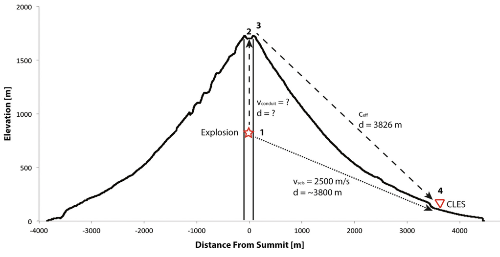
Breakdown of propagation paths for the seismic and acoustic waves between an explosion at depth and a seismo-acoustic station 3.5 km away. Figure from Iezzi et al. (2020), Frontiers
|
Coupled seismic and acoustic analyses can be used to help understand shallow to subaerial explosion sources, including buried chemical explosions and volcanic eruptions. At Mount Cleveland volcano, Alaska, a variable seismo-acoustic time lag of up to 2.20 s is observed by co-located seismo-acoustic sensors at a station 3.5 km from the summit, suggesting a change in propagation path for the signals between explosions.
Atmospheric effects were examined using two independent measurements, neither of which could entirely explain the variation observed. Nonlinear propagation impacts were determined to be minimal in relation to the onset time of the infrasound arrival, though they were difficult to quantify and model completely. We find that results from seismic cross-correlation and particle motion analysis suggest that a varying explosion source depth within the conduit may play a role in the observed variations in seismo-acoustic time lag. |
Related Publications:
Iezzi, A.M., Fee, D., Haney, M.M., and Lyons, J.J. (2020), Seismo-Acoustic Characterization of Mount Cleveland Volcano Explosions, Frontiers in Earth Science. | (link)
Blom, P.S., Iezzi, A.M., and Euler, G. (2020), Seismoacoustic analysis of underground explosions using the Rayleigh integral, Geophysical Journal International, 223, 1069–1085. | (link)
Infrasound Source Directionality
|
While traditional infrasound sensor deployments are often constrained to Earth’s surface, we performed an infrasound deployment at Yasur volcano that included sensors suspended from a tethered aerostat have shown that portions of the radiated acoustic wavefield may be missing from ground observations.
A simple (monopole) source mechanism that radiates sound equally in all directions is often viewed as a good approximation for discrete volcanic explosions, but a small directionality (dipole) component may remain. In this project, we used 3-D Green's functions and waveform inversion procedures to obtain an estimate of erupted mass and directionality, which was shown to be consistent with ballistic directionality at Yasur volcano, Vanuatu. |
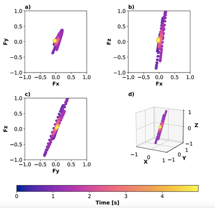
Directionality of an example explosion at Yasur volcano, Vanuatu. Figure from Iezzi et al. (2019), JGR
|
Related Publications:
Iezzi, A.M., Fee, D., Kim, K., Jolly, A.D., and Matoza, R.S. (2019), Three-Dimensional Acoustic Multipole Waveform Inversion at Yasur Volcano, Vanuatu, Journal of Geophysical Research: Solid Earth, 124, 8679-8703. | (link)
Jolly, A.D., Matoza, R.S., Fee, D., Kennedy, B.M., Iezzi, A.M., Fitzgerald, R.H., Austin, A.C., and Johnson, R. (2017). Capturing the Acoustic Radiation Pattern of Strombolian Eruptions using Infrasound Sensors Aboard a Tethered Aerostat, Yasur Volcano, Vanuatu. Geophysical Research Letters, 44(19), 9672-9680. | (link)
Diaz-Moreno, A., Iezzi, A.M., Lamb, O.D., Fee, D., Kim, K., Zuccarello, L., and De Angelis, S. (2019), Volume Flow Rate Estimation for Small Explosions at Mt. Etna, Italy, From Acoustic Waveform Inversion, Geophysical Research Letters, 46, 11071-11079. | (link)
Long-Range Infrasound Propagation Modeling in Alaska
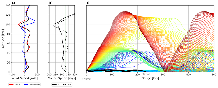
Example propagation modeling figure during the 2019 eruption of Shishaldin volcano.
|
Alaska’s over 50 historically active volcanoes span 2,500 kilometers, and their eruptions pose great threats to the aviation industry and local populations. Due to relatively weak attenuation in the atmosphere at these low frequencies and strong ducts in the atmosphere, infrasound can propagate hundreds to thousands of kilometers under suitable conditions and be detected by infrasound sensors, either at an array or on single sensors. However, long-range infrasound propagation is greatly affected by winds and temperature gradients in the atmosphere.
To accurately constrain volcanic source information and understand the long-range propagation, a detailed characterization of the spatial and temporal variability of the atmosphere is vital. We use a combination of array processing and propagation modeling to refine interpretations of infrasound detections, differentiate between possible atmospheric propagation paths, and understand detection performance at each array. |
Related Publications:
Iezzi, A.M., Schwaiger, H.F., Fee, D., and Haney, M.M. (2019), Application of an updated atmospheric model to explore volcano infrasound propagation and detection in Alaska, Journal of Volcanology and Geothermal Research, 371, 192-205. | (link)
Schwaiger, H.F., Lyons, J.J., Iezzi, A.M., Fee, D., and Haney, M.M. (2020), Evolving infrasound detections from Bogoslof volcano, Alaska: insights from forward modelling, Bulletin of Volcanology, 82. | (link)
Schwaiger, H.F., Iezzi, A.M., and Fee, D. (2019), AVO-G2S: A modified, open-source Ground-to-Space atmospheric specification for infrasound modeling. Computers and Geosciences, 125, 90-97. | (link)
* In addition to journal publications related to this research, we have implemented our propagation modeling as a forecasting tool at the Alaska Volcano Observatory, which has been used in real-time for eruptions including Pavlof 2016, Bogoslof 2016-17, and Shishaldin 2019.
Modeling Lahar Inundation Using Historical Flow Deposits
|
Redoubt Volcano is an ice-covered stratocone in south central Alaska whose eruptions often trigger lahars that travel 35 km down the Drift River valley.
We modeled the largest lahars from the three most recent eruptions to better predict the area of inundation during future eruptions. Using GIS and the lahar simulation program Laharz_py, inundation models were created and compared with the known mapped area of post-eruption inundation done by the USGS for the seven most extensively studied lahars spanning the three most recent eruptions of Redoubt volcano, Alaska (1966-68, 1989-90, and 2009). The input data for these simulations consisted of a ten-meter resolution DEM and estimates To capture the specific characteristics of the Redoubt Volcano lahars, a retrospective manipulation of the calibration factors was performed, such as the starting coordinates of the lahars, using the previously mapped areas of inundation. |
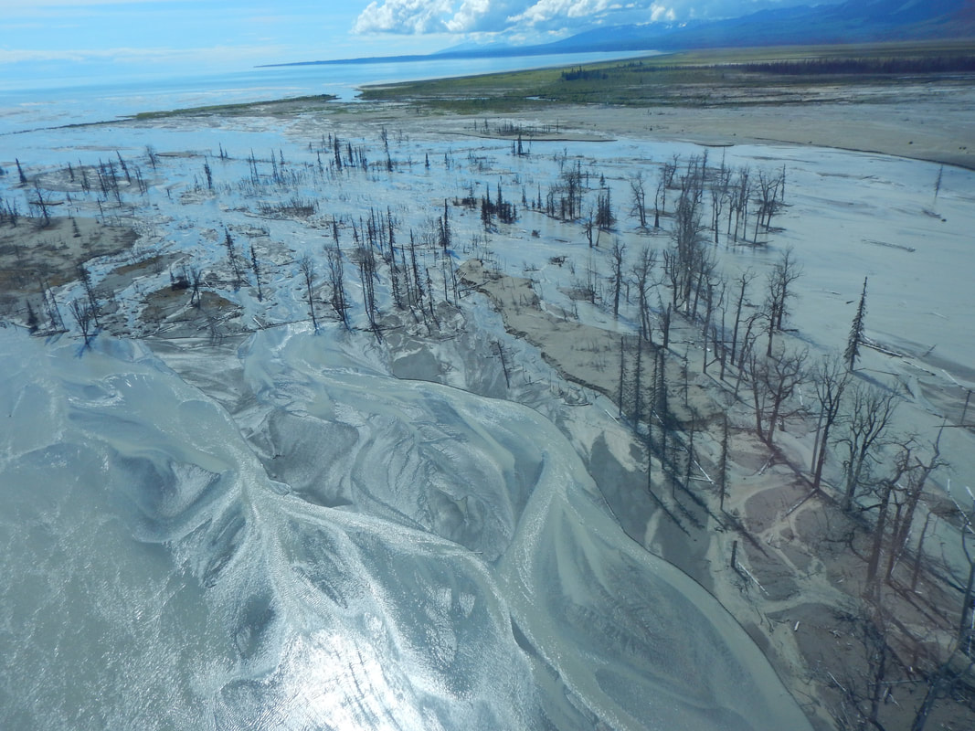
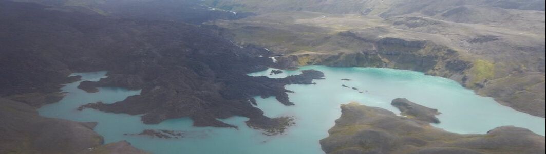
Photo of the 2009 lahar deposits where the Drift River valley meets Cook Inlet, taken in 2015.
|
Related Publications:
Iezzi, A.M. (2015), Modeling Lahar Inundation with the Aid of Historic Flow Deposits at Redoubt Volcano, Cook Inlet, Alaska. Connecticut College Physics, Astronomy and Geophysics Honors Papers. Undergraduate Honors Thesis, 1-160. | (link)
Iezzi, A.M. (2015), Modeling Lahar Inundation with the Aid of Historic Flow Deposits at Redoubt Volcano, Cook Inlet, Alaska. Connecticut College Physics, Astronomy and Geophysics Honors Papers. Undergraduate Honors Thesis, 1-160. | (link)
